Everyone is familiar with 3d visualisations in archaeology. From Gladiator to Time Team, these CGI models are ubiquitous. However, in the discipline of Archaeology itself, 3d visualisation has gone through a period of dwindling enthusiasm. It is seen as an expensive way to bring archaeological interpretation to the masses. But a few bright spots have emerged from the end of Archaeology's honeymoon with 3d. Here is my whirlwind tour of what's cool at present in the world of archaeology and 3d.
3d Recording
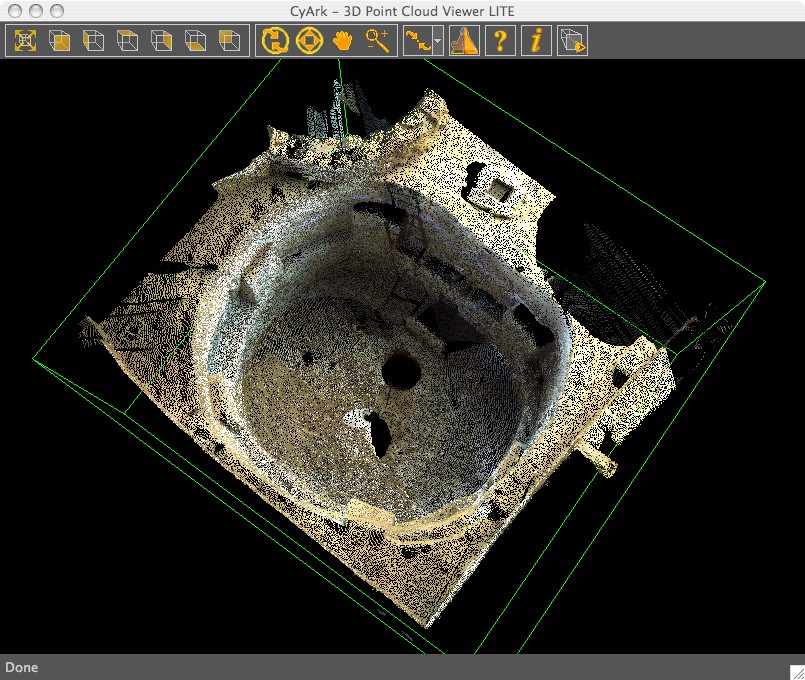
The convergence of powerful but affordable personal computers and methods for the rapid capture of 3d data has rescued archaeological VR from its decline into use solely as an illustration tool. Leading the way in the 3d recording revolution is laser scanning. A modern theodolite records 3d coordinate data one coordinate at a time. A laser scanner can record hundreds of points in a matter of seconds. The density and accuracy of this recording creates clouds of 3d points which are the equivalent of making a cast of the object or site being surveyed. The point cloud is so detailed, so complete and so rapidly generated that the temptation to use the technique for as many archaeological recording tasks as possible is very strong. There are major laser scanning projects active throughout the world with one of the most ambitious being conducted by the father of practical laser scanning Ben Kacyra. He has founded Cyark, a non-profit organisation that seeks to record and therefore digitally preserve as many important heritage sites as possible throughout the world. The fruits of this Herculean labour are available for all at http://www.cyark.org. Login and begin exploring the world of point clouds and laser scanning.
There are other ambitious scanning activities closer to home too. The Glasgow city council has commissioned the creation of a 3d urban model created by laser scanning every building within the Glasgow city centre. English Heritage has completed their evaluation of laser scanning and has published their definitive guide to the subject. For many examples of laser scanning in action, just search for 'laser scanning' on YouTube. Especially cool are the videos made from various laser scans such as the landscape around Stonehenge produced with Lidar by Wessex Archaeology:
DIY Laser Scanning
When going through the YouTube offering you will notice that, despite proper laser scanning equipment costing hundreds of thousands of pounds, for around £30 anyone can make a laser scanner. It won't scan whole buildings, it's not terribly accurate, it's not even true laser scanning, but it is a fun toy and will allow you to capture the general geometry of small to medium-sized objects. The best DIY laser scanning is the David Laserscanner, the software for which is free. All you need is a line laser, a computer and a webcam. The user gallery demonstrates some of the excellent results that are possible with this system.
Photogrammetry
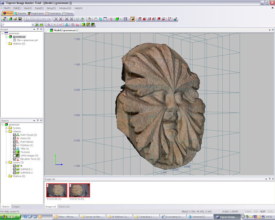
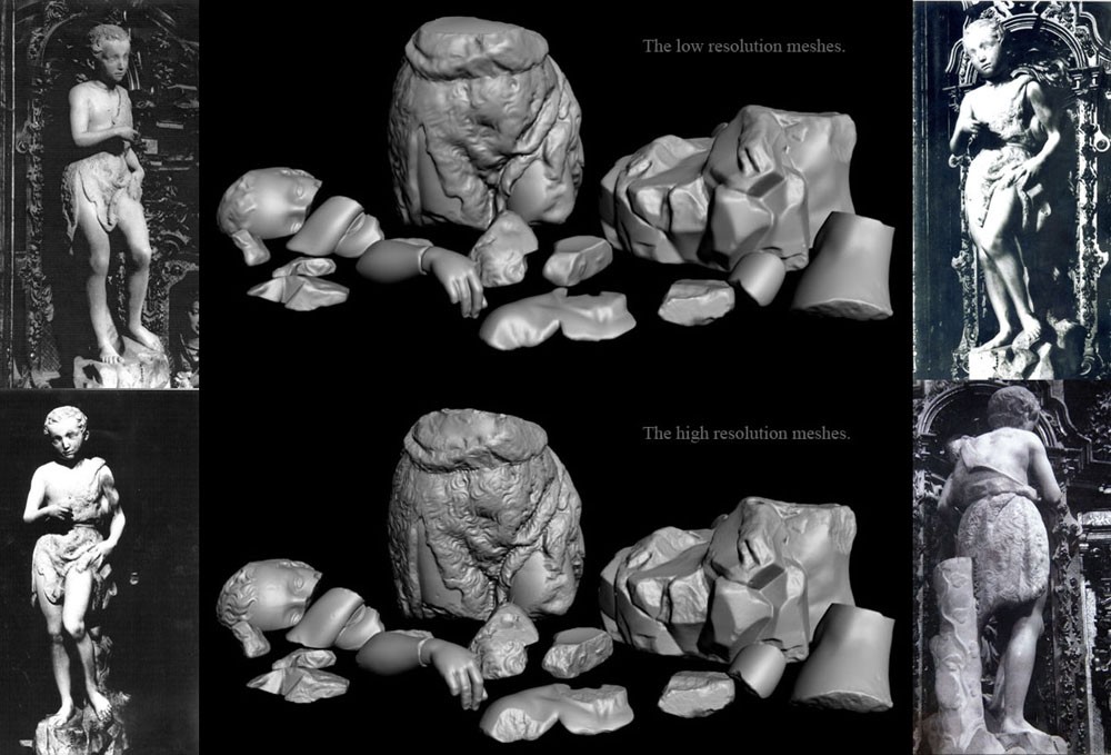
Of course, as I said, the David Laserscanner is not true laser scanning in that it does not rely on the laser for measurement. Any sharp, thin, bright line of light will work for this method. This is because this method is a 'structured light' method which is, at its core, photogrammetry. And photogrammetry is the leading challenger to laser scanning as a means of rapid measurement in 3d archaeology. It is cheaper (a few thousand pounds for professional-quality equipment and software), more portable (all you need is a camera), sometimes quicker, includes imagery as well as geometry, and can be just as accurate (depending on the subject and the setup). Photogrammetry has been used for decades in archaeology to create line drawings of sites in 3d. However, advances in computer vision research have made it possible to capture not just line data but surface geometry as well. The tool of choice for English Heritage and archaeological organisations (including this Archaeology Department) is a program called Imagemaster (aka PI-3000). A free viewer and many useful demo datasets are available from the UK supplier TerraDat. There are alternatives. For many years a far less expensive but more labour-intensive and lower-grade photogrammetry package called Photomodeler is available. Photomodeler now has sister software that is capable of capturing 3d surface data just like Imagemaster - Photomodeler Scanner. While by no means perfect, this surface modelling technique is powerful and accessible. If you want to try it out yourself (and are studying at York), just let me know and you can use the Department's version of PI-3000.
Of course, there are cheaper ways of doing photogrammetric modelling. If you'd like to work with less dense pointclouds in a more Photomodeler manner for free give Insight3d a try. This seems to produce automatic point clouds similar to those created by Photosynth. As I have said elsewhere, Microsoft appears to have not grasped the modelling potential of its Photosynth software. This is probably one of the easiest and cheapest ways to do image-based modelling. There are numerous archaeological/buildings examples with Richard Haddlesey's Great Titchfield tithe barn the most impressive in terms of its audacity (photogrammetric modelling of the interior of a timber building is difficult). While the people at Photosynth still seem to see their software as a fancy photo album, there are ways to extract the 3d data behind the 'synths' and these have led some to use it as a free photogrammetry tool.
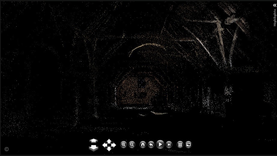
Also free and capable of producing models more like those in Imagemaster/PI-3000 or Photomodeler Scanner is the Arc3d Web Service. It's a bit hit-and-miss (I've never managed to hit, but I haven't spent that much time with it), but the gallery of projects that have worked is impressive. To work with the data files Arc3d generates you need the even more impressive and cool tool Meshlab (which can also be used to edit and cleanup models produced by PI-3000 and David Laserscanner)
Augmented Reality
3d data capture is the category of greatest growth driving 3d applications in archaeology. However, there are other areas where there are cool developments too and this is important since I have yet to see a convincing example of what one can usefully do with all of this 3d data. Perhaps one of the most interesting possibilities is Augmented Reality. Augmented Reality essentially overlays a layer of computer-generated content over a stream of video, typically from a webcam. Perhaps the most accessible AR tool is the AR Media Plugin for Sketchup. This takes advantage of the free CAD program Sketchup and allows users with a webcam to 'magically' display an interact with their Sketchup models in realtime simply by moving a specially tagged piece of paper within the view of the webcam. Sound confusing? Watch the video below and you'll see the potential of this kind of technology.
By the way, watch some of the other AR videos on YouTube. Some are truly amazing. Archaeologists were early explorers of this technology with the Archeoguide project creating a fully immersive AR headset to allow visitors to sites to see models of reconstructed ruined buildings in realtime. Another interesting, and here potentially lucrative development, is AR for mobile devices but, as in so many things, interest in this seems to have dwindled in recent years. If you want to have a go at it yourself and don't want to buy the Sketchup plugin, then you can go to the AR sources - ARTag or ARToolkit and build your own AR applications for free - almost.
Game Engines
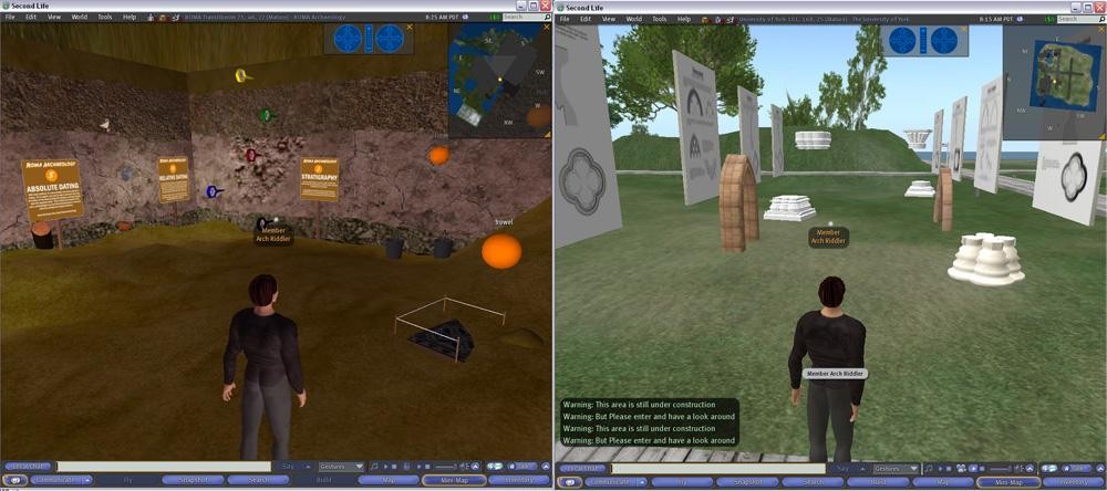
Taking a step further into archaeological virtual reality is the use of game engines and virtual worlds to represent archaeological and cultural data. This category is far more difficult to evaluate and pursue because it changes daily with many examples vanishing from the web overnight. At present there are a few interesting examples. First, though it may be showing its age, Second Life offers an interesting platform for archaeology. There is a virtual Catal Hoyuk (image) to visit and the Roma area provides an interactive tour of archaeological field practice (image). The University of York also owns an island which is somewhat empty but has a few contributions. One is the big red ADS cube — the Second Life home of the Archaeology Data Service. There is also a small underwater element about the Venus Project (one of the most ambitious archaeological VR projects ever) and a small dig is out back. Beside the ADS cube is a growing assortment of architectural fragments which is meant to be a 3d virtual guide the basics of English medieval architectural history.
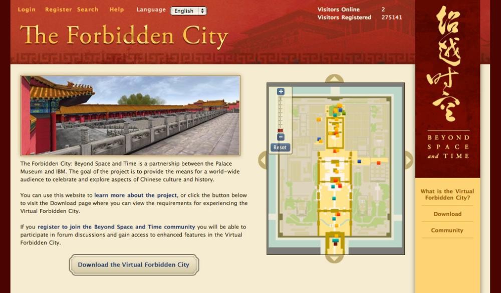
Beyond Second Life there are dedicated game environments with an archaeological or a material culture interest. One of the most interesting possibilities is the Virtual Museum of the Ancient Via Flamina at Rome. Here there is a rather large download of a standalone virtual environment which includes a reconstruction of the Empress Livia's villa (beware, it's a big download). What is so interesting about this is that is uses laser scanning data of the present-day site as its basis for reconstruction. Also, there are three levels of display which help the user to understand how much the reconstruction relies on archaeological data. The most ambitious archaeological visualisation in a game engine, however, is the online Forbidden City. Sponsored by IBM, this game allows you to experience life in the pre-modern Forbidden City in Beijing. There are tours, games, fights, artefacts and a fairly active online community (thanks to Sha Gai for bringing my attention to this project). At the other end of the archaeological gaming spectrum is the (unholy?) alliance between historical/archaeological research, visualisation, and assassination that has resulted in Assassin's Creed. What warrants a mention here is that it is extremely popular, beautiful to watch, and based (at least in part) on a visualisation of Palestine at the time of the Crusades. Whether the 15th century Venice of Assassin's Creed 2 is as concerned with its historical and archaeological background remains to be seen.
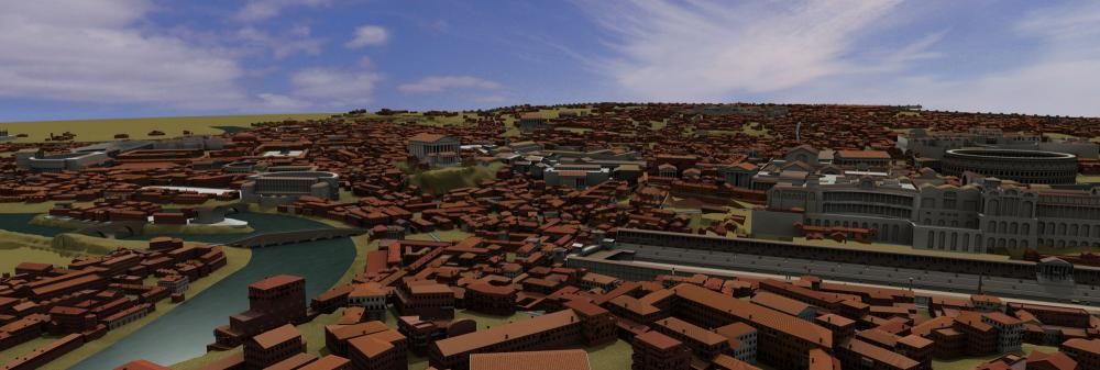
Urban Complexity
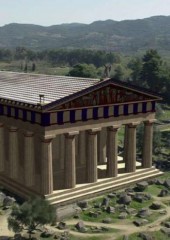
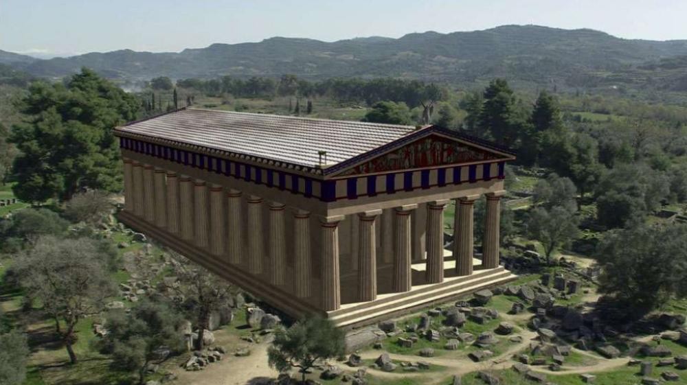
The impressive complexity of the virtual Forbidden City begs the question of how the untidy reality of life can be represented in the too often sterile environment of 3d computer graphics. One final toy deserves a mention. In most of these archaeological visualisations, massive amounts of data are visualised. But what about the gaps in the data? Even the most complete archaeological investigation will leave many, many details unknown. An excavation can reveal the plan of a ruined city, but it cannot reveal every aspect of every above-ground feature of every building. This is where CityEngine is potentially important. It is an engine for procedurally (i.e. the computer constructs the model based on rules and models provided by the user) building cities based on plans and a set of rules for combining architectural elements. The largest archaeological visualisation to date, the Rome Reborn project, uses CityEngine to visualise the housing infill between the well-known monuments (thanks to David Harker for showing me this site). It is truly impressive. Using this, vast cities can be reconstructed in a manner that avoids repetition and suggests the complexity of past urban landscapes. Similar procedural modeling in the future could help insert that level of 'messy' complexity that is an important but difficult to visualise part of the human past.
References
- Masinton, A. (2008) 'Review of ImageMaster Close-Range Photogrammetry Software by Topcon' in Internet Archaeology, 25.
Related Articles
- Photogrammetry Using PI3000 in Issue 1