During the summer field schools of the University of York Archaeology department, between 2007 and 2010, Year 1 students were taught how to conduct a graveyard survey. This often involved the participation of PhD and Year 2 students as supervisors and worked to the methods pioneered by the former department lecturer Harold Mytum in his book Recording and Analysing Graveyards (Mytum, 2000). Memorials at Easingwold church was recorded between 2007 and 2009, with Heslington completed in one summer project, that of 2010. The former is now part of the North Yorkshire Graveyards Survey project, while the latter will be added soon.
Sadly, in the reorganisation of fieldwork undertaken for the 2010/11 student intake, graveyard survey is no longer taught to Year 1 students at York. This is unfortunate as it inspired a number of current Year 3 students, who learned the techniques in 2010, to choose the subject for their dissertations, myself included. Here I will outline some of the history of the subject, the techniques, my own experiences of dissertation fieldwork and some potential problems of the discipline.
Harold Mytum was not the first to outline the principles of graveyard survey; Burgess (1963) laid some of the groundwork, taking the discipline away from its roots in the art history movement for the first time. He was followed by Jones (1976) who drew up the first 'instruction manual' which was at the time aimed mainly at genealogists and local history groups. Mytum built upon these to produce his own work (2000) and has also written extensively on the subject in other books and journal articles since the 1990s. He is not the lone authority in the field however, with Sarah Tarlow producing strong work studying graveyards in the Orkney Islands (Tarlow, 1999) and such publications as that by Dethlefsen and Deetz (1966) looking at American cemeteries.
For my own survey I chose a church reasonably local to me; St. Helen's in the village of Skipwith, North Yorkshire. It is an area where I do a lot of volunteer archaeology work with a local group, the Friends of Skipwith Common.
This area has an interesting background, with the common hosting man-made remains dating from the Bronze Age to World War 2, and most significant periods in between also present in some form (Blythe and Quartermaine, 2008). The site of the church itself had a limited archaeological survey carried out in 2008 when rebuilding work was done on the tower, allowing archaeologists a rare chance to dig under and around the church as well as looking at the building in general. The survey produced evidence of burials from the Saxon period, reused Roman stonework in the church fabric, a Viking depiction of the Ragnarok legend carved into stonework in the inner tower and twenty-four reused Medieval cross slabs (grave covers) lining the outer perimeter wall (Hall et al. 2008); hence a site with a long and complex history.
Having sought and received permission from the local Reverend to do the survey and established that there are 375 external grave markers in the churchyard, I decided to use GPS to locate them on a plan. Having borrowed the equipment and used it to plot in the various stones, I discovered that partly due to operator error (me) and the unsuitability of that particular type of GPS unit for such detailed work, the results were unable to be used. I then decided, in consultation with my dissertation supervisor, that measuring in the 375 markers using tape survey and plotting the measurements into an AutoCAD drawing programme was the way forward.

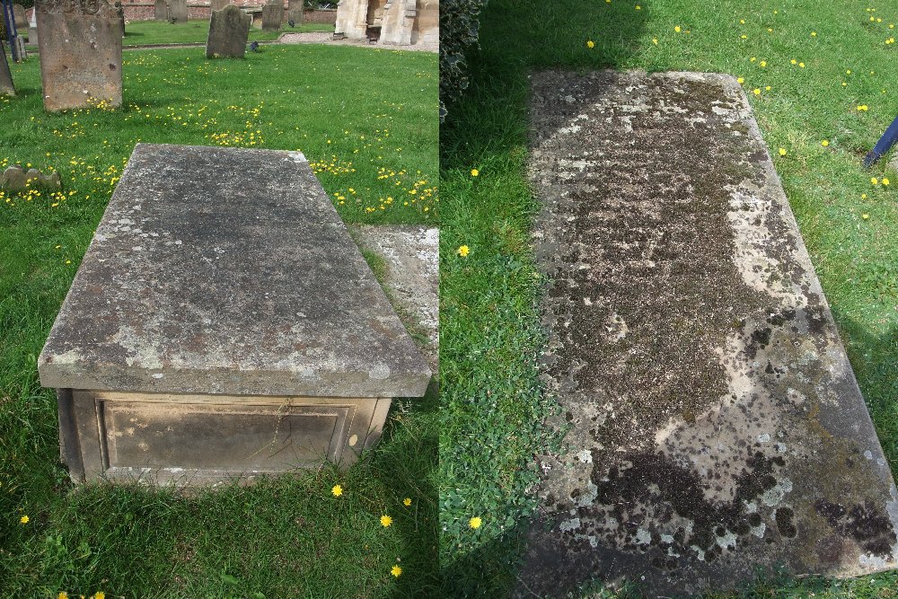
First though, I needed to identify each stone. Using the standard form available in Recording and Analysing Graveyards (Mytum 2000, 81) I began recording the inscriptions and major details of the grave markers. These included a unique reference number (001-375), details of the condition of the stone, the height, width and the length (for flat ledger slabs and chest tombs) or thickness (for standard headstones). The orientation for the vast majority was an east/west alignment, with just a handful differing from this for various reasons. Also recorded was the type of memorial, from a pre-set series of codes and styles (Mytum, 2000), any additional decorations and the style/font of lettering used. I decided not to record material types (as I know little about geology) and inscription techniques, as neither of these would prove useful to the direction of my dissertation research. One of the best things about the Mytum system though is that it leaves the recorder free to include or exclude whichever data their particular survey is interested in (Mytum, 2000).
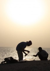
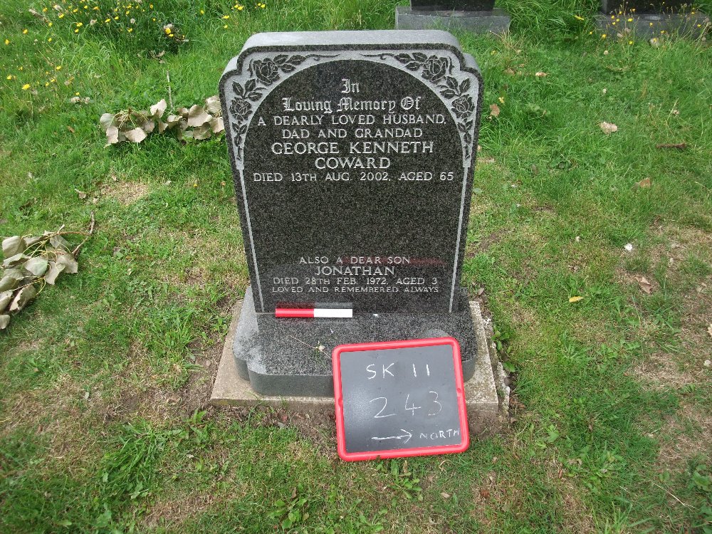
Once this phase of the fieldwork was complete, the next could begin. In my case, this was the photography section. For this I purchased a small blackboard and chalks from the Early Learning Centre in York (a bargain at ?6) and had created for me by my father a simple 20cm scale bar. I was also able to borrow a two metre ranging pole from my local volunteer group, though I only used this when photographing the larger memorials.
Thus equipped I was ready to begin. The Site Code (SK11) was chalked onto the blackboard, along with the memorial number and an arrow showing North. This was then placed alongside or in front of the memorial, with the scale bar and, if used, the ranging pole, and the photograph taken (see Figure 2).
A number of factors made this a slower process than expected. Limited camera battery life, even at fully charged, meant I could only photograph around 90 memorials at a time. Another unexpected problem was long grass. Four different people cut the grass at St. Helen's, and each does their own area differently. One likes to keep the grass quite long, which made it difficult to walk through and hard to get a clear view of the inscriptions. I had to return to photograph some a second time, as parts of the blackboard were obscured.
This was eventually completed and I moved on to the final phase of the fieldwork; the tape measure survey to replace the lost GPS data.
Having had a brief refresher on this technique from a department expert, I borrowed some long tape measures and started measuring. This is little different from some of the techniques of buildings survey, which is still part of the field school training programme. A series of baselines are needed, each running off from a known point on a previous baseline and themselves measured to fixed points around the churchyard. From these, measurements are taken for each memorial, the number of measurements depending on the memorial type. For mine I used one measurement to a small memorial (vase or cremation plaque), two to a standard headstone (one at either side) and four to ledger slabs and chest tombs (one to each corner) (see Figure 3). Each set of measurements is taken from a known point on a particular baseline, then a second set is taken from a different point (and sometimes a different baseline). This gives a series of figures that can then be put into an AutoCAD drawing programme to produce an accurate map of the graveyard.
This was the one aspect of the fieldwork I got help with, and even then it took two and a half days to record the figures for all 375 memorials. In all, my fieldwork took me a total of 22 survey days, between the beginning of July and mid October 2011.
Graveyard survey can be a very satisfying experience. It is something that can easily be done alone (though a second person is useful if doing a tape measure survey) and the fieldwork can be managed during the summer break between Years 2 and 3 of a degree.
There are a number of directions from which the research can be tackled. Mine is to look at the social changes taking place in a rural Yorkshire village over the period of the 19th to the early 21st centuries. A friend is looking at the power and status of individuals from the materials used for their memorials, with a particular emphasis on local Coniston slate. Two very different uses of similar data from a similar time period.
I can say from my own point of view that I have enjoyed my dissertation, that the fieldwork was interesting to do, occasional setbacks aside and that I look forward to completing it. A copy has already been requested for lodging in the archive of St. Helen's church.
In conclusion, graveyard survey is very rewarding, whether done as part of a team as the students of 2007 to 2010 did, or individually as I and others in Year 3 have done for our dissertations. For anyone who is interested in learning more, the books produced by Burgess (1963), Jones (1976), Tarlow (1999) and Mytum (2000) can be borrowed from the University of York library services.
Bibliography
- Blythe, K. & Quartermaine, J. (2008). Skipwith Common, North Yorkshire: Outline Landscape Survey. Lancaster: Oxford Archaeology North.
- Burgess, F. (1963). English Churchyard Memorials. London: Lutterworth Press.
- Dethlefsen, E. & Deetz, J. (1966). Death's heads, cherubs and willow trees: experimental archaeology in colonial cemeteries. American Antiquity 31(4), p502-510.
- Hall, R. A., Kendall, T. & Briden, C. (2008). St. Helen's Church, Skipwith, North Yorkshire. The Archaeological Journal 165, p399-470.
- Jones, J. (1976). How to Record Graveyards. London: Council for British Archaeology.
- Mytum, H. (2000). Recording and Analysing Graveyards. York: Council for British Archaeology.
- Tarlow, S. (1999). Bereavement and Commemoration: An Archaeology of Mortality. Oxford: Blackwell Publishers.