Improvements in technology have been aiding archaeologists since the birth of the modern profession. But never has the pace of development been so fast and so far-reaching in its application. As a result, the onus today is not just on long-standing professionals, but on the new generation of archaeologists to understand this technology and to apply it to archaeology, so that our profession remains vibrant and in touch with today. Furthermore, those outside the subject still perceive our subject as antiquated and reluctant to use new technologies. Today I will show you how this technology has been adapted to archaeology by the New Generation. The aims of this paper are to show how the new generation are looking to apply new technologies to their work, to critique their use in relation to older applications of technology, and to look towards future technologies and their viability.
Gary Lock noted the distinction between automation and innovation ten years ago, and it remains vitally important (Lock 2003). Automation is the computerisation of methods and techniques that are already apparent, and innovation is the use or invention of new ideas, methods or equipment. The distinction between the two can seem very blurred to begin with; at what point does the use of a Geographic Information System in an excavation become innovative, for example? While it may look innovative by bringing the museum into the household, are these features simply automating tasks that are already being done by the museum? Technology actually becomes a threat when used incorrectly, especially when a technology becomes very popular and becomes the norm in society.
The second problem is preservation and dissemination in the modern day. In particular, with climate change, the likelihood of natural events exposing archaeological sites, but also destroying them, is becoming more common, and conventional methods of recording sites are becoming too time-consuming or unaffordable. There are a large number of sites that were exposed over the winter of 2014 in Britain alone that went potentially unrecorded. So can archaeology adapt to this? The third problem is the rise of the internet. Archaeology has not embraced the internet’s potential, which is now used by a third of the world’s population and practically 99% of the UK’s population. Many of us don’t blog about our work which is a missed opportunity. Furthermore, internet technologies which are free or affordable, particularly in relation to photogrammetry, have become very common but simply aren’t known (Galt 2014). There are so many ways the internet can help us, but we leave the potential to computer scientists, so their work trickles down to us. So what is the new generation doing about these problems?
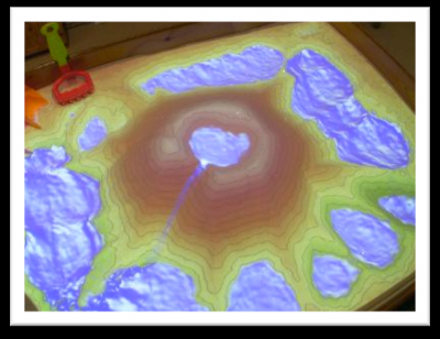
Noble-Shelley was inspired by the use of the “excavation in a box” activity (a sandpit to teach children how archaeologists excavate sites) by the Hampshire and Wight Maritime Archaeological Trust to adapt the Xbox Kinect into its use (Noble-Shelley 2013). This involves using a projector and a Kinect in tandem to both capture the movements of participants, the movement of sand, and to also project an image of the site, which helps with stratigraphic interpretation and the visualisation of a site, thus creating an “augmented reality” (which can also be seen on a separate screen for other participants) (Figure 1). Originally, the software (which is free) for the Kinect’s use in this way, was developed by Oliver Kreylos from the University of California Davis, for explaining geological and hydrological principles by using sand as a “tapestry” for modelling water. The innovation comes in taking this technology and making it into an archaeological game that allows people who otherwise can’t get involved, such as children, or those with a disability, to participate in an excavation. It allows for people to be immersed into the excavation. The Kinect also stands up well against older “virtual reality” excavations, which were primarily on websites. These shouldn’t be considered true virtual digs as there is no interactivity, they are not as engaging, and are often very unwieldy websites to use, such as the Grand Pre excavations in Canada (http://www.grand-pre.com/en/8b30-36.html). Furthermore, other uses of the Kinect in archaeology, such as the Roskilde ”Experience Cylinder”, charting the 2007 voyage of a Viking ship from Denmark to Ireland, have not focused on the teaching of excavations. But, it is very limited in its further educational value at the moment; there is no further use beyond the activity itself, as of yet, except in videos, though there is scope to develop it so that a user could use their Kinect at home to excavate a virtual site, without the need for a sandbox.
Arch Aerial is combining innovations from multiple fields. Based in Texas, they design drones which allow archaeologists to take aerial photographs (and they are currently working on installing LiDAR into these). It is innovative because it uses a 3D printer in the design process; this allows the trial and error stage of creating the product to be done wholly in the office, cutting costs significantly without compromising on quality, and making the product accessible to archaeological projects. The idea came from an Italian excavation where the expensive use of helium balloons meant that there were only a few aerial photos to show for a whole season’s work. The drones have multiple advantages over other techniques; mainly the versatility and the reusability of the drones, but also their durability in many environments and climates, making them reliable. The drones are quite small, and are built out of polymer (AVS plastic). They can be easily integrated into any site. They can fly between 20 and 300 metres to capture sites of basically any size within one picture. Compared to conventional drones, which cost between £15 and £35,000, Arch Aerial drones can be hired out for less than £1,000 for 3 months. Drones themselves are innovative because you can easily use the photographs from the drones to create photogrammetric plans and models in about 20 minutes from downloading the photos into the software; they can be used to help with the day-to-day interpretation of the site; a kind of “interpretation at the lens edge”?
Although the drones have only been used on a few archaeological sites, they have already significantly increased our understanding of the sites they have visited. For example, in Belize, they discovered a whole number of new sites by flying around the canopy of the Belize rainforest. Today, we can also use photogrammetry for variety of applications in archaeology, using software like Agisoft. But, you can also use free software such as Sketchfab to publish these models for free (Barratt 2013).
At the same time Arch Aerial is automating the process of aerial photography, making it easier to take repeatable, high quality photographs of the site. However, very little in the way of theory has been applied to drone usage on sites. To me, it is primarily a question of scale: is it just about photographing the site, or placing the site into a pattern in a landscape? The act of zooming into an image can be interpreted as a top-down interpretation of a site, while zooming out of an image could be construed as a bottom-up approach. Aerial photography was the domain of air survey specialists, and to some extent, this leads to the archaeologist’s knowledge of aerial photography being sketchy at best. This has led to the limited use of aerial photography, sometimes using photography for economic or ergonomic reasons rather than for genuine archaeological enquiry. This has also led to a lack of critique of the theory and method, not in the sense of interpreting features. As an analogy, how we came to understand how to use GIS properly in archaeology was only really done when we critiqued how statistics were being used within GIS. For example, Figure 2 and 3 explicitly shows the degrees of distortion, where the 45 degree angle in the corners represents a 1.44 times increase in the length of the distance between the camera and the ground (Wilson 2000).
The use of the internet in recent years has expanded almost exponentially. With the expansion in technology, this has also allowed new and innovative methods of practising and publicising archaeology; for example, any archaeologist who uses social media to engage with a wider audience than their peers. Many archaeologists have blogs and social media accounts, and mention their work, research, and other articles, discussing among their peers about current issues, and so on. This is not just broadcasting however; this is also a one-to-one engagement with the public, our main audience. Effectively, the excavation or museum exhibit can come to them without the expense of travelling.
I would argue that social media is changing the very way that we as archaeologists are teaching people, and by definition, it is also changing the way the entirety of academia is being taught by breaking down barriers created through centuries of tradition. But this is on a whole new scale; affecting people from all walks of life, finally offering a viable alternative, for all ages and abilities, by being relatively cheap and accessible. This brings me to the crux of my argument: it is my sincere belief that every archaeologist should, if they haven’t already, be given basic training in social media so they can reach their target audience of the public. Why is one-to-one engagement more important than just presenting articles to the public? Because we are simply not doing enough to keep the public engaged with archaeology. Social media provides a simple and under-valued solution to this fundamental issue. This is not just a case of “keeping up with the times”; our raison d’etre is at stake; if we cannot inform the public of our work, then why does our profession exist? While other professions exploit this technology in many ways, we struggle to keep up.
In having said this, the near future may well bring us a new medium to interact with the public: Minecraft and the ‘gamification’ (definition from Ng 2014 – using elements of games in non-game settings) of social media. Charlie Brooker’s documentary Videogames Changed the World shows us that the future may well lie in the gaming industry, in particular with social media and games that can exploit this. Minecraft is a cheap “sandbox” game that allows you to create and destroy blocks to your desire, and is often used to recreate objects from real life, like cities. Because of its community element, where several people can be on the same server, real-life skills like team work, communication, and creativity can be developed in a safe environment. It has become a very powerful tool in educating children and adults alike, from fields as diverse as architecture, town planning and human geography. In schools, there is a version of Minecraft called MinecraftEDU (http://minecraftedu.com/page/), which is designed to complement a school’s curriculum, although the link between archaeology and schools is still a work in progress. Minecraft has thousands of “mods”, which add additional content to the game, but as of yet, the closest thing to archaeology is a comedy version of archaeological excavations which is designed for fun, and not to be taken seriously. This is a resource that could be developed for future generations of people to enjoy archaeology, much like Jasmine’s Xbox is treated like a game by children at the Hampshire and Isle of Wight Maritime Trust; but also as a tool for presenting and educating the public in general. This is not to say that it should replace conventional methods of displaying archaeology, but that it should be treated as a complementary resource.
In conclusion, the innovative solutions to real world problems can be found in new technology, not just in academia. Much of the technology presented here is now becoming free or affordable, allowing archaeology to adapt more easily. However, it should be considered at the start of any research project whether this technology would be useful for you, by putting the archaeology first and not the technology. In many cases it needs to "lose its innocence", with more theoretical critique.
Acknowledgements
I must thank Jasmine Noble-Shelley for allowing me to see her dissertation and presenting it at two conferences on her behalf! I would also like to thank Ryan Baker, CEO of Arch Aerial, for our informal chat over Google Hangouts in February 2013, and Lucy Shipley, who also gave invaluable time to talk about the use of the 3D-printed drones over the site she was excavating on. Finally I would like to thank Eric Walker of AIS Kuwait school, who provided information about resources relating to MinecraftEDU.
Bibliography
- Author unknown, 8B30-36. Société Promotion Grand-Pré. Accessed via http://www.grand-pre.com/en/8b30-36.html [Accessed 14 April 2014].
- Barratt, R. P. (2013). The Use of Photogrammetric Models for Recording of Archaeological Features. The Post Hole Journal, York University. Accessed via https://www.theposthole.org/read/article/237 [Accessed 14 April 2014].
- Clarke, D. (1973). Archaeology: The Loss of Innocence. Antiquity, 47, pp. 6-18.
- Colley, G. (no date). Best Practice in the use of UAV and Low-cost software for Photogrammetric Surveys of Heritage sites. Suave Aerial Photographers. Available via http://www.suaveairphotos.co.uk/newsletters/Newsletter4/SuaveISPRS2011Be... [Accessed 14 April 2014].
- Galt, A. (2014). 3D modelling for Archaeologists. 14 April 2014. Available via www.archserve.blogspot.co.uk [Accessed 14 April 2014].
- Lock, G. (2003). Using Computers in Archaeology: Towards Virtual Pasts. Routledge: London.
- Ng, K. (2014). UNESCO uses Gamification to Teach Disaster Safety. Asia Pacific Futuregov. 17 January 2014. Available via http://www.futuregov.asia/articles/2014/jan/17/unesco-uses-gamification-... [Accessed 14 April 2014].
- Nilsson, D. (2010). The Usage of Unmanned Aerial Vehicles and Their Prospects in Archaeology, Master’s Thesis, Institute of Archaeology, Lund University, Sweden.
- Noble-Shelley, J. (2013). The Kinect: Potential and Application Within Archaeological Education and Outreach. Unpublished undergraduate dissertation, Southampton University.
- Rempel, D.E. (2013). Gaming for Mastery: Using a Content-Specific Video Game to Increase Student Engagement and Self-Efficacy in English Criterion A: Content. Research Report in Fulfilment of SCED 695.
- Videogames Changed the World. Channel 4, Endemol UK, 30th November 2013, Television.
- Wilson, D. R. (2000). Air Photo Interpretation for Archaeologists. Tempus, Stroud.
Appendix
Image 1: Kreylos, O. (2013). Augmented Reality Sandbox. Fig.1: Sandbox table when turned on, showing a mountain with a crater lake, surrounded by several lower lakes. Available via http://idav.ucdavis.edu/~okreylos/ResDev/SARndbox/ [last accessed 14 April 2014].
Images 2-3: Tuck, A. Kriendler, K and Huntsman, T. (2013). Excavations at Poggio Civitate (Murlo) During the 2012-2013 Seasons: Domestic Architecture and Selected Finds From the Civitate A Property Zone. Fig 3: Civitate A: Overhead View of the Area of Excavation. (Photo by Ryan Baker and Nathan Palacios, Courtesy of Poggio Civitate Excavation). In Etruscan Studies, 2013; vol. 16(2), pp.287-306.


