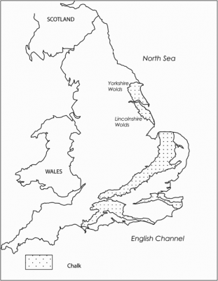
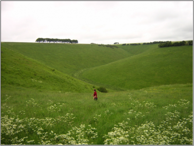
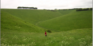
The chalk Wolds of East and North Yorkshire comprise a lightly settled rural landscape dominated by agricultural activity and they are the northernmost expanse of English chalk, forming an arc between the Humber Estuary and Flamborough Head (Figure 1). The Wolds rise steeply from the Vales to the north and west, and more gradually from the plain to the east, to a maximum height of 200m above ordnance datum, covering an area of 1350km². The area is characterised by deeply incised dry valleys and low rolling hills (Figure 2). There is a general absence of surface watercourses on the Yorkshire Wolds, with the Gypsey Race the single exception, and even this is seasonal in places. There are geological contrasts in this region, with the soft drift of Holderness, the chalk Wold ridge and the sandstones of the North Yorkshire Moors compressing a wide range of landscape diversity into a relatively small area (Roberts and Wrathmell 2000, 47).
The distinctive inverted ‘L- shape’ of the Yorkshire Wolds, results largely from the folding of the chalk that took place during the Tertiary period, and this resulted in the shallow syncline that forms the Lincolnshire and Yorkshire Wolds (Catt 1987, 13). Towards Holderness in the east, the chalk dips below substantial Quaternary deposits and towards the west. For example, in the Vale of York, there are a series of older Triassic rocks (Catt 1987, 16). Towards the centre of the syncline the chalk is c.500m thick but at its southern limit is anything from 50 to 230m thick. Drift deposits are rare on the Wolds and are restricted to two units of glacial till occurring in Holderness and the lower part of the Wolds dip-slope (Catt 1987, 16).
This concentration of prehistoric monuments on the Yorkshire Wolds has led to comparison with prehistoric Wessex. In addition to the barrows, linears and cursus monuments, there are exceptional features from other periods of time such as square barrow cemeteries, ladder settlements, chariot burials, villas, deserted medieval villages and Anglian cemeteries. An assessment of the Yorkshire archaeological resource has found that the Wolds landscape contains large volumes of artefacts representing all categorised periods of time from the Neolithic onwards (Roskams and Whyman 2008).
The richness of archaeology is evident due to the lack of concentrated modern settlement that would potentially destroy or mask archaeological features, although arable intensification and deep ploughing does pose a considerable threat. Despite the history of archaeological study, the region has not benefited from a rigorous programme of environmental work and the palaeoenvironmental context of the archaeology itself is relatively unknown. In addition to this, a lack of understanding of landscape processes within the dry valleys on the Yorkshire Wolds has been problematic for scholars from both the earth sciences and archaeology for a long while (Lewin 1969, 3; Foster 1985, 206; Hayfield and Wagner 1995, 49; Manby et al. 2003, 113).
‘Wold’ is thought to derive from Old English ‘wald’, meaning wood and is usually applied to lightly spread woodland, often described as ‘wood-pasture’, with little or no plough land (Fox 2000, 51). Woodland itself is rarely mentioned specifically in Domesday and so it is suggested that ‘wald’ may have been derived from the Latin ‘gualdus’, referring to land rights over marginal areas that were in royal control but had common access rights (Fenton Thomas 2005). It is thought that some areas of ancient woodland survived into the seventeenth century and that several of the Scandinavian place names, including the deserted medieval villages of Argam and Skali, mean ‘on a seasonal basis’, indicating a transhumant mode of settlement (Fox 2000, 52). Evidence from text, but also focused on the regionally unusual chalk, emphasises the marginal character of the Yorkshire Wolds landscape for settlement, and there is a continuing debate about the possible continuity of settlement in the area since prehistoric times. Whilst we recognise the concentration of prehistoric monuments, we have limited understanding of the locus of broad human activity: whether this was concentrated around the monuments themselves, and the nature of their relationship to the wider landscape (Bradley 2002, 41).
In addition to prehistoric and historic period landscape modification, significant landscape changes have influenced the topography of the Yorkshire Wolds during the last century. The chalk grassland, which was once the predominant mosaic vegetation, now covers just 1.3% of the Wolds due to an increase in arable land during the twentieth century, and also because of changes in the methods of farming as part of agricultural intensification (English Nature 1997, 3). Although there has been significant habitat loss, many man-made habitats such as disused quarries, disused railway cuttings and scree surfaces now provide typical grassland habitats, demonstrating the complex relationship between people and the places they modify. Sparse woodland is present here with calcareous ash woods, shelter belts and dale head plantations, but habitat diversity is considered low due to the farming methods employed. The use of agricultural chemicals and widespread re-seeding has led to a 35% loss of calcareous grassland habitat during the 1980s alone (English Nature 1997, 9). There remain, however, twenty Sites of Special Scientific Interest (SSSIs) on the Wolds, testifying to the importance of this landscape for ecological and environmental heritage and equilibrium. The hawthorn hedgerows, resulting from Parliamentary Enclosure (1750–1850), are now being removed because of intensification and this is considered, by some, a return to an earlier open landscape character.
A combination of agricultural and central water abstraction has lowered the water table and caused spring-flow reduction, thereby lowering the levels in seasonal streams or winterbournes. Additionally, water quality, in this substantially agricultural area, is easily contaminated by the use of the chemicals associated with agricultural intensification, such as farm effluent, pesticides and leachates (English Nature 1997, 15). There has been the widespread loss of dewponds (man-made ponds lined with layers of quicklime, straw, clay and chalk rubble), with an estimated 80% of the total number falling out of use between the 1950s and 1980s (English Nature 1997, 11).
The nature of the pre-Quaternary landscape of northern England is difficult to establish due to successive regional ice sheets and large-scale glacial erosion during the Pleistocene. Despite significant research into the pre-Pleistocene evolution of northern England, there are still many more questions than answers about the overall development of the north during the Tertiary period (Huddart and Glasser 2002, 29). The cliffs at Sewerby, East Yorkshire, are of national and international importance containing evidence for environmental change since at least the last interglacial (Evans 2002, 71). The features seen include an Ipswichian interglacial beach deposit dating to c.132,000 m.y.a., sediments resulting from the drop in sea level at the beginning of the last glacial period and evidence for the advance of ice into the area during the Dimlington Stadial (Evans 2002, 71). Although the Yorkshire Wolds were unglaciated during the Devensian, as a periglacial region, the subsoil would have remained frozen throughout the entire year (Ahnert 1998, 103). It is however, entirely possible that some of the dip-slope features may have been caused by the full glaciation of the Yorkshire Wolds, and this has not been conclusively discounted (Lewin 1969; Foster 1985, 36). Geomorphological and sedimentary analysis demonstrates that the ice advanced further into East Yorkshire than previously appreciated (Foster 1985, 1). An attempt to delineate the advance of the Late Quaternary ice sheet in the Yorkshire Wolds was unsuccessful due to the poor quality of the data retrieved. The analyses revealed higher blown sand content than expected which is probably indicative of a glacial outwash deposit (Foster 1985, 1). Unsurprisingly, this study found a close correlation between the underlying tectonic framework and the surface landscape development of the Yorkshire chalk.
Versey considered the nature of hydrology in East Yorkshire in 1949, and provided detailed calculations demonstrating the ability of the chalk Wolds aquifer to provide all the mains water required for domestic and industrial needs in the East Riding and Hull. However, he also described the problem of understanding the perched water tables within the aquifer which arise from the marl bands which separate layers of chalk. These marls represent the insoluble residue of dissolved chalk and the resulting clay deposits frequently seal the joints between the chalk layers. Even when the marl band is very thin, it may be sufficient to form a watertight barrier to percolation (Versey 1949, 239). It is this effect that results in very different results for water table heights between boreholes which are very close geographically. The extent of the chalk aquifer in the Yorkshire Wolds and the Holderness Plain covers an area of 2000km² and the only surface flow on the outcrop is the Gypsey Race in the Great Wold Valley, with the River Hull rising as a series of springs south of the chalk outcrop (Salmon et al. 2007, 413). The chalk here, belongs to the ill-defined northern chalk which is materially different from the chalk in the south of England (Salmon et al. 2007, 413). The hydrogeology of the area was assessed and the study found pronounced fissuring and the development of secondary permeability especially within a zone of water table fluctuation within the dry valleys themselves (Salmon et al. 2007, 414). There is an absence of modern water intrusion and marked seasonal variation in the spring-flow; the application of a numeric model underestimated low flows in the seasonal stream of the Gypsey Race and in the streams and becks that issue from the chalk edge (Salmon et al. 2007, 414).
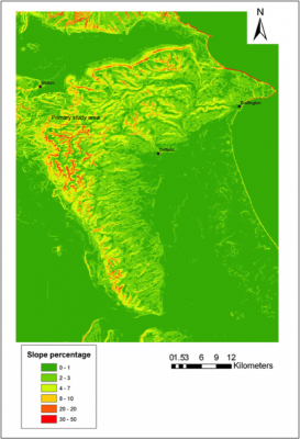
In the nineteenth century the Reverend EM Cole of Wetwang became the first to specifically comment on the formation of the East Yorkshire dry valleys. He deduced that erosion responsible for valley formation had occurred largely by annual meltwater runoff from an active area of Devensian regional permafrost. This theme was taken up by Mortimer (1885) in the late nineteenth century. As part of his discussion into the formation of the valleys, Mortimer mentions ‘the very few existing streams now running for short distances along some of the valley bottoms’ and that they could not be related to the vast numbers of water sources needed to excavate the valleys themselves. Mortimer (1885, 30-31) states that such imaginary streams would have to, in any case, ‘run in opposite and in every direction’. Mortimer suggests that the valleys were created by cracks and fissures in the chalk surface due to the elevation of the chalk onto dry land, and that the cracks have been subject to natural forces which have subsequently widened them (Mortimer 1885, 34) (Figure 3).
Versey (1949) suggests three likely explanations for the range of dry valley axes seen in the Yorkshire Wolds. Firstly, the obsequent valleys (flowing into another stream but in the opposite direction to the slope of the land surface) have most likely been developed due to spill-over lines from an ice front to the west of the Wolds escarpment. Some others seem to have been formed by the erosion of frozen chalk, and others still by the collapse caused by solution hollows (Versey 1949, 242). A topographic field study of the geomorphology of the dry valleys in the Yorkshire Wolds was undertaken four decades ago (Lewin 1969). The escarpment features on the Wolds are making analogy with other regions problematic (Lewin 1969, 17). Water moves through the body of the chalk via joints which are often identified by looking at valley axes, but in the Wolds there is no consistent valley direction to imply sub-surface jointing patterns (Lewin 1969, 4) suggesting a similar periglacial origin as the patterns seen in the Chilterns.
Lewin made an assessment of the morphology of all the dry valleys on the Wolds, but found that typological classifications were of limited use because the valley networks vary so considerably (Lewin 1969, 46). He found that most dry valleys are developed irregularly and abruptly onto otherwise smooth slopes, giving the appearance that they are a late addition to an earlier landform (Lewin 1969, 51). There were three factors that he found of particular relevance. Firstly, that there is a general angularity of the confluences. He also found that adjacent valleys often ran in a consistent direction but that neither angularity nor alignment is in sympathy with the general slope and this is more closely related to joints and faults in the underlying chalk (Lewin 1969, 47). The third significant finding relating to valley patterning, is that the valley heads are very variable, being either rectangular, sharply cut or dendritic onto the adjacent interfluve.
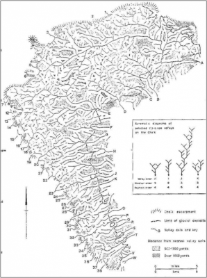
The features arising from solution collapse on the Yorkshire Wolds are on a massive scale, that is unique for England (Lewin 1969, 56). The valley networks themselves are variable, with frequent dendritic and converging systems (Lewin 1969, 38) (Figure 4). Drainage densities are difficult to assess because of the variability in valley size from the head to mouth, and surface density estimates are limited because the water movement is largely underground (Lewin 1969, 39). Looking at the morphology of a valley can give an indication of past landscape processes; for example, the five large meanders in the Great Wold Valley suggest very high water flow at some point in the past (Lewin 1969, 51).
The valley floor gravels here are waterlain, the upper surface has been altered by cryoturbation during periglacial conditions (Foster 1987, 37). As Harris (1961, 2) suggested, the bottom of valleys provide an excellent settlement location with shelter from the wind and the elements, and access to water via springs and shallower wells than would be possible at the top of the slopes. However, during heavy rain, the effects of flooding might be felt more strongly here. Many small villages and hamlets are strung out along the valley floor, especially in the High Wolds, but this type of settlement is more difficult to identify archaeologically due to the nature of methods such as aerial photography which are dependent on the depth of buried features, current land-use and tend to favour eroded sites. Archaeological patterning is dependent predominantly on sites revealing themselves through processes of denudation or by methods which rely on shallow deposits for their success. Occasionally an ancient site in the valley bottom is revealed, as was the case at Burdale within a broad valley (an Anglian site, and our departmental field school site in 2006/7). In a landscape concentrated on the deeply incised slacks and dales of the Yorkshire Wolds, it is likely that past settlement is concentrated in precisely the locations that are most difficult to ‘see’ and to investigate by conventional methods.
Bibliography
- Ahnert, F. (1998) Introduction to Geomorphology. London: Arnold
- Bradley, R. (2002) ‘The Neolithic and Bronze Age periods in the North’ in C. Brooks, R. Daniels and A. Harding (eds) Past Present and Future: the Archaeology of Northern England. Durham: Roger Booth Associates. 30–37
- Catt, J. A. (1978) ‘The contribution of loess to soils in lowland Britain’ in S. Limbrey and J. G. Evans (eds) The Effect of Man on the Landscape: the Lowland Zone. CBA Research Report 21. London: CBA. 12–19
- English Nature. (1997) The Yorkshire Wolds Natural Area Profile. Available at: www.naturalareas. naturalengland.org.uk [Consulted 2005]
- Evans, D. J. A. (2002) ‘Sewerby’ in D. Huddart and N. F.Glasser (eds) Quaternary of Northern England Geological Conservation Review Series No. 25. Peterborough: JNCC. 71–77
- Fenton Thomas, C. (2005) The Forgotten Landscapes of the Yorkshire Wolds. Stroud: Sutton.
- Foster, S. W. (1985) ‘The Late Glacial and Early Postglacial history of the Vale of Pickering and the northern Yorkshire Wolds’. Unpublished PhD thesis, University of Hull
- Fox, H. (2000) ‘The Wolds before 1500’ in J. Thirsk (ed.) The English Rural Landscape. Oxford: Oxford University Press. 50–61
- Harris, A. (1961) The Rural Landscape of the East Riding of Yorkshire 1700–1850. Oxford: Oxford University Press
- Hayfield, C and Wagner, P. (1995) ‘From dolines to dewponds: a study of water supplies on the Yorkshire Wolds’. Landscape History. 17. 49–64
- Huddart, D and Glasser, N. F. (2002) Quaternary of Northern England Geological Conservation Review Series No. 25, Peterborough: JNCC
- Lewin, J. (1969) The Yorkshire Wolds: A Study in Geomorphology. Occasional Paper 11. Hull: University of Hull
- Manby, T. G, King, A and Vyner, B. (2003) ‘The Neolithic and Bronze Age: a time of early agriculture’. In T. Manby, S. Moorhouse and P. Ottaway (eds) The Archaeology of Yorkshire : an assessment at the beginning of the 21st century ; papers arising out of the Yorkshire Archaeological Resource Framework Forum Conference at Ripon, September, 1998. Leeds: Yorkshire Archaeological Society. 35–113
- Mortimer, J. R. (1885) ‘On the origin of the chalk dales of Yorkshire’. Proceedings of the Yorkshire Geological Society. 9. 29–42
- Roberts, B. K and Wrathmell, S. (2000) An Atlas of Rural Settlement In England. London: English Heritage (Folio F 1.42 ROB)
- Roskams, S. P. and Whyman, M. (2005) ‘Yorkshire archaeological research framework: a resource assessment’ Report 2936 for YARFF and English Heritage
- Salmon, S, Chadha, D. and Smith, D. (2007) ‘Development of a groundwater resource model for the Yorkshire Chalk’. Water and Environment. 10 (6). 413–422
- Stoertz, C. (1997) Ancient Landscapes on the Yorkshire Wolds. Swindon: RCHME
- Versey, H. C. (1949) ‘The hydrology of the East riding of Yorkshire’. Proceedings of the Yorkshire Geological Society. 27. 231–246


