It is inevitable, with the rapid pace at which technology has been evolving recently, that even in the field of archaeology, a process of modernisation is underway.
GIS data is constantly being utilised to create accurate plans of sites, LiDAR creates surfaces that can be used to point out underlying features and Access databases have revolutionised the way we organise records. The list of computer-based methods which are the foundations of archaeological investigations is vast.
One of the methods of recording which only has recently been developed to the point of being suitable for field archaeology is Photogrammetry, which allows the creation of 3D models using series of photographs of an object or a feature. Although it is not a recent concept, only in the last few years have we moved on from having to carefully measure the position of the camera at every shot, to being able to use photos taken much more freely (Chandler & Fryer 2011).
Background
The idea of using Photogrammetry as a means of recording archaeological features was first explored during the 2012 excavation at Ham Hill, Somerset, carried out by the Cambridge Archaeological Unit in association with Cardiff University, and the excavation at Caerau, Cardiff, also by Cardiff University. In these instances features of particular note were recorded using 123D Catch, which lets you create 3D models from photographs, and the finished models were uploaded to sketchfab.com for the general public to view. Artefacts were also recorded in this manner, and they received positive interest on social networks by people interested in the outcome of the excavation.
Although the initial intention was simply that of providing a new and interesting way of presenting archaeology to the general public, the wider potential of this technology can already be seen, as the models created in these two sites provide an extremely detailed record of how the features would have looked when the photos were taken. As such, would it be possible to use the same methodology with the sole intention of recording an archaeological feature, and can it work alongside traditional methods of recording to provide a more accurate representation of the archaeological finds?
In an attempt to shed light on the potential of Photogrammetric recording, during the 2013 excavation of Ham Hill, a number of features have been even more carefully recorded with Photogrammetry with the clear intention of testing the limits and advantages of this method.
Programs required|
Many programs allow the creation of Photogrammetric models from photographs, but for this project the one chosen was 123D Catch by Autodesk. The main reason for this choice is the availability and simplicity of the program, which is complemented by good accuracy. Previous unpublished work by the author suggests that 123D Catch provides an error margin of less than 1% (Figure 1), although it is based on smaller objects, while Chandler and Fryer (2011) have achieved reconstructions with less than 0.17% error. Programs like AgiSoft PhotoScan should provide even higher accuracy due to a larger number of points being created in each mesh, but while 123D Catch is freeware, PhotoScan is a commercial product which as such may not be available to all. Ducke, Score and Reeves (2010) suggest an alternative and more accurate approach, yet the process requires a number of programs, some of which are less than user friendly.

As a result 123D Catch is a good compromise between accuracy and accessibility, making it a tool available to all, simple to use, and one that still creates high quality meshes.
123D Catch creates a complete mesh which means no alteration or additional user input is required, and as such it is not equipped with more advanced tools of model manipulation. However, in some situations described later on, it may be necessary to alter the mesh. As a result, the model can be exported as an object file and opened with the program MeshLab (also freeware), which provides a series of tools to scale, glue and filter the mesh.
A last mention should go to the website sketchfab.com, which allows users to upload models that can then be shared or embedded on other websites. The main advantage of this is organisation, as the models can be placed in different galleries and are easily accessible both to the uploader and to those who may require access to the data.
Methodology
An overview on how to use 123D Catch can be found on the program’s website (http://www.123dapp.com/catch), yet for the recording of features it is worth pointing out a number of details that can help the creation of good models.
The models that are used for the purpose of the argument here were made using approximately 20 photographs each, which consisted of 8 photos taken at a relatively consistent height with a 45° change between shots, 8 shots at a lower angle, 1 shot of the feature as a whole from above, 1 shot of each section in detail and 1 of the base of the feature. The number of shots however depends on the shape of the feature, and if it is slightly more complex it may require additional photographs to emphasise certain areas. The photographs don’t require excessive accuracy when being taken, i.e. there is no need to measure precisely the position of the camera each time, provided that it is roughly similar to the ones mentioned.
For the purposes of the models here a PENTAX *ist DS camera was used, with the settings left on automatic to further emphasise the accessibility of this methodology, even for those who do not possess vast photographic experience. The photographs were not altered in any way as that could impede the working of 123D Catch. The images were saved in .jpeg format, which is the standard file type with which the program works. With this setup the finished model should be produced without any difficulty, however with some more complex features, manual stitching may be required. A discussion of problematic features is provided later on.
Features recorded
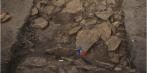
A large number of features were successfully recorded using Photogrammetry from both Ham Hill and Caerau, ranging from postholes to large stone spreads. Excavated sections from Ham Hill of Bronze Age and Romano-British ditches in particular proved to be easy to record, as well as storage and deposition pits. Some in situ finds were also recorded to provide context once they were removed from the ground, including a number of pottery spreads within pits and articulated bones from a number of features.
Given the size of the sites, it was not possible to complete all features, so a larger emphasis was placed on those that appeared to be either more challenging or unique, in order to stress the conditions and test the limits of the technology.
The features were also recorded using traditional methods, but given the research nature of the excavation, comparisons between the two methodologies are harder to make, hence this paper is more interested in noting the advantages of Photogrammetry as an addition to traditional methods, rather than a replacement.
All models recorded have been uploaded to http://robbarratt.sketchfab.me, and the most poignant for the argument are shown in the Figures section.

Results: additions to traditional methods
The rapidity and precision with which the features were recorded seem to suggest that Photogrammetry can be an invaluable tool for recording features. Far from being technology for technology’s sake, it provides additional information that may be only partially kept with traditional recording, and it condenses most of the data into one singular object rather than having a number of plans and context sheets that have to be consulted together.
The main way this is achieved is through the addition of the third dimension, which allows the 2D plans to come to life. In traditional plans, the hachures can be somewhat confusing, and they are far from a precise method to record the depth of a feature due to the impossibility to standardise the distance between them. The depth is recorded in the context sheets and as such it is not lost information, yet often a single measurement is taken as an example for the average depth of the entire feature, not taking into account the changes within the surface (Figure 1 & 2).
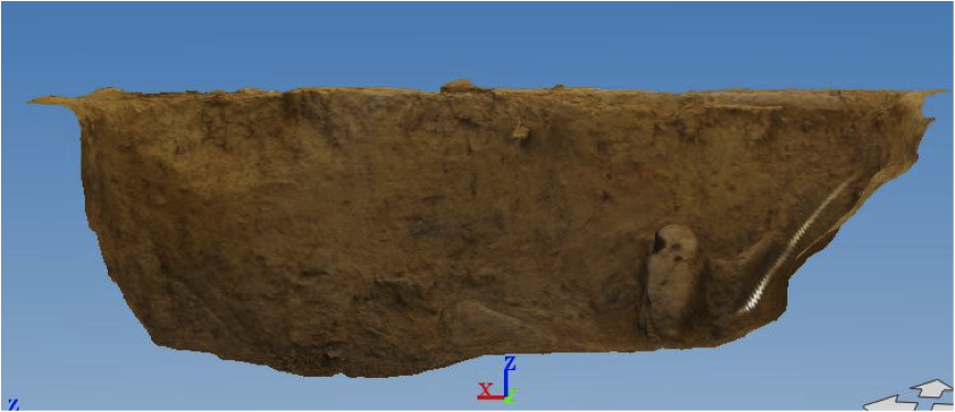
Similarly the slope of a feature is recorded both in the plan and the context sheet, with an accurate description given of how it appears to the eye of the excavator. This again though can be subjective and can only give a limited idea of what the surface actually looks like. Photogrammetric models represent clearly how the slope progresses, and make it possible for the person interpreting the data to draw his own conclusions on the nature of the feature (Figure 3).
Sections can also be successfully recorded using this method, either as part of a larger model of the entire feature or as a separate entity (Figure 4). These models combine section drawing and photography, and by using MeshLab, it is possible to draw lines within the model in order to show the separation between the different contexts, meaning that the interpretation of the excavator, who would have actually experienced the changes of soil first hand, is not lost.
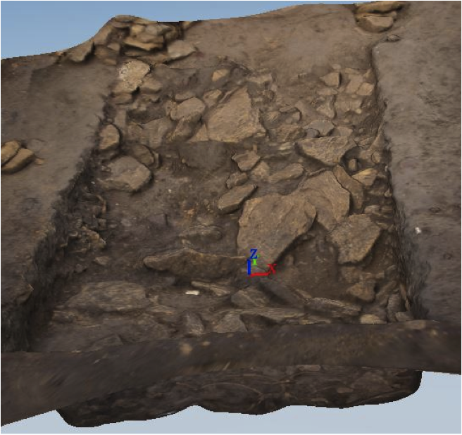
For stone spreads it is ideal, as it gives a precise image of the position of all the stones, which are also hard to record by hand using a grid (Figure 5). The abundance of contrast between the stones and the soil also makes it much easier for the program to recognise points, making the finished model even more accurate.
Finally, provided that a measurement between two points has been taken as a form of reference, it is possible to accurately scale the model to real-life size, and through the use of MeshLab measure the distance between different parts of the models in order to get real life measurements. Again, the addition of the third dimension means that this measuring process is as precise as actually doing it on the feature itself.
Results: limitations|
As competitive as Photogrammetry may sound, at the moment it does present a number of limitations that mean it cannot be used by itself. The main issue is the unreliability of the software. Simple features are easy to model, and present little need for manual stitching. However larger features, or features that present more complex characteristics (pits within features, stone structures, adjoining ditches) often result in partially completed models, with holes within the surfaces, or even no models at all. When using Photogrammetry on a feature there is also a chance that the finished model may not be satisfactory, and given the need of internet for the program to work, it may take time to realise the problem, by which point the feature may be lost. Manual stitching can help complete the models with holes in them, and sometimes even a model that has entirely failed can still be recovered by uploading a small amount of photos and then slowly manual stitching the rest. However this is a long process and requires good knowledge of the program, as well as a certain quantity of luck, and as such it is certainly not the ideal method. In addition to this, although the process itself is extremely fast, interpreting the data from the model can be less than so.
MeshLab itself is an unreliable program, with the additional issue of not being able to undo the previous action. Setting up a reference distance and measuring off it requires calculations to be made in order to alter the scale the right amount. Drawing lines to separate sections is less complicated, but it also looks less professional, making it unsuitable for publications. The potential of Photogrammetry itself is strongly connected to the 3D aspect of it, and as such it cannot compare with plans and sections in publications.
Finally, being objective in the recording process is important for some aspects, especially for features for which the interpretation is uncertain, but when drawing a plan or a section, the excavator filters it using the knowledge he or she has gained from the excavation of the feature itself, something which is hard to replicate using Photogrammetry.
A compromise
Due to these limitations Photogrammetry cannot be used on its own as a method of recording. On the other hand though, the advantages derived from it are enough to justify an addition of this method to the more traditional ones, especially considering the rapidness with which it operates. A model with 20 photographs can take as little as 5 minutes to photograph and 10 minutes to process, which is extremely short considering the much longer processes of planning and section drawing. Therefore it is possible to argue that the time lost making the model is justified by the additional information gained from it.
Conclusion
Consequently the work done at Ham Hill with Photogrammetry suggests that as a method of recording it has great potential, if used alongside plans, section drawings and context sheets. Its main advantages are the rapidity of the process, the ability to convey in a clear manner the shape of the edges and the depth of a feature, as well as condensing much information into one entity. The issues that still persist though are the unreliability and complexity of the software, the unsuitability for publication and the lack of interpretation derived from it. Overall Photogrammetry should certainly be explored further as a technology and introduced into the field as a standard method of recording.
Reference List
- Chandler, J. and Fryer, J. (2011) Accuracy of AutoDesk 123D Catch? Available at: http://homepages.lboro.ac.uk/~cvjhc/otherfiles/accuracy%20of%20123dcatch... [Accessed 9 May 2013].
- Ducke, B., Score, D. and Reeves, J. (2010) ‘Multiview 3D Reconstruction of the Archaeological Site at Weymouth from Image Series’. Computers & Graphics. 35. 375-382